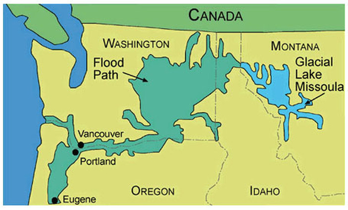
WHAT WERE THE MISSOULA FLOODS?
The Missoula Floods were a series of floods that occurred in the Pacific Northwest between 18 000 and 15 000 years ago - at the end of last ice age [1]. They were a cataclysmic type of flood called a Glacial Lake Outburst Flood. They were unimaginably large. During, peak discharge they had a flow rate of 17 million m3/s.This makes them the 2nd largest floods ever discovered after the ancient Kuray Floods. Overall, there were roughly 40 floods an average of 50 years apart [2].
Source: Idaho State University http://geology.isu.edu/Digital_Geology_Idaho/Module13/LakeMissoula.jpg
Glacial Lake Outburst
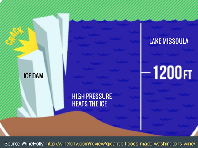
A glacier is a large body of dense ice and they covered in dense ice Northern Washington, Montana and Idaho towards the end of the last ice age. A glacial lake outburst occurs when, a lake of water is held in place by a glacier and that glacial dam then breaks to release the water. Lake Missoula formed due to a glacier which blocked the a river (the Clark Fork River). The Lake was about 2184km3 and built up pressure on the glacier. The high pressure of the water increased the water temperature and caused cracks in the ice at the bottom of the glacier [3].
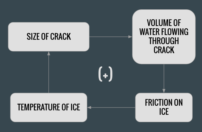
The Ice Crack-Water Friction Feedback Loop
The pressure induced cracks started a feedback loop. Water flows through the the cracks in the ice dam, this creates friction which heats the temperature of the ice crack, the ice crack then melts and becomes larger, more water then flows through the ice crack which creates more friction. This occurs low down on the dam where the pressure is highest and continuously accelerates weakening the dam until the whole thing fails. The feedback loop is shown below [4].
The Flood
When the ice dam broke, a 400ft-600ft tall river of water was released traveling 60-80 mPh. Lake Missoula drained and it rushed across 7800km3 of Washington. These floods shaped landscape of Washington, Idaho & Montana as they Moved hundreds of cubic km of sedimen. The volume of water was so great that it may have affected oceanic circulation and the global climate [5].
The video below shows one entire cycle of the Missoula Floods.
Source: https://www.youtube.com/watch?v=G_LRo3wIT34
Citations:
[1] US Geological Survey, Department of the Interior http://pubs.usgs.gov/circ/2004/circ1254/pdf/circ1254.pdf
[2] http://www.waterencyclopedia.com/Bi-Ca/Bretz-J-Harlen.html
[3]] US Geological Survey, Department of the Interior http://pubs.usgs.gov/circ/2004/circ1254/pdf/circ1254.pdf
[4] http://www.pbs.org/wgbh/nova/transcripts/3211_megafloo.htm
[5]] http://www.waterencyclopedia.com/Bi-Ca/Bretz-J-Harlen.html
