This activity requires Google Earth. If you do not have Google Earth you can download at this link - http://www.google.com/earth/download/gep/agree.html
Good, now that we are all on the same page we can begin.
We have created a georeferenced layout of points of interest for the Missoula Flood. Your job is to determine which photo and description fits the location shaped by the Missoula Floods based on what you now know about both the flood and greater geomorphic processes. Try to think about what this landscape would have looked like before and during the floods because what you see now is the aftermath.
Please download this .kmz file, it will automatically open Google Earth when you open the file. Also please take out a sheet of paper to write your answers on.
| missoula_floods_earth_systems_science.kmz |
Each description and photo here matches one of the points (labeled A - J) on the map. Can you figure out which goes with which? Some are harder than others so if you can't get one skip to the next. The answers are at the bottom. No Peeking!
|
1. Camas Prairie Ripples
These giant ripple marks have an average height between 13-30 feet and dwarf any ordinary ripple mark you might find on a beach or in a river today. The marks were formed as the deep and swift flowing water from Glacial Lake Missoula raced through the failed ice dam at speeds up to 80 miles per hour. |

Source: http://wordpress.ed.pacificu.edu/jclark/files/2011/11/The-Missoula-Floods-Layer.kmz
|
|
2. The Mouth of the Columbia
The floodwaters reached the mouth of the Columbia River with such strength and force that they deposited sediment 700 miles away in the Pacific Ocean. |
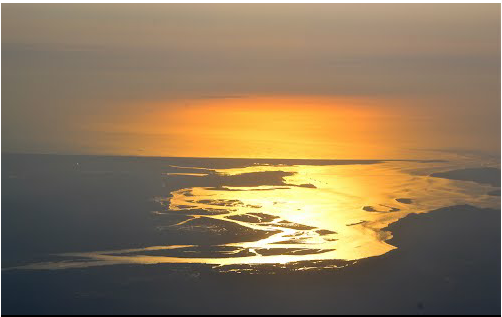
Source: Google Earth User - Buddy Rogers
|
|
3. Clark River Valley Ice Dam
During the last ice age, from approximately 20,000 years ago, the Clark Fork Valley lay along the southern edge of the Cordilleran ice sheet covering western North America. The encroachment of the ice sheet formed an ice dam on the river, creating Glacial Lake Missoula which stretched through the Clark Fork Valley across central Montana. The periodic rupturing and rebuilding of the ice dam released the Missoula Floods down the Clark Fork and Pend Oreille into the Columbia which sculptured many of the geographic features of eastern Washington and the Willamette Valley of Oregon. When it burst through the ice dam and exploded downstream, the waters of Glacial Lake Missoula ran at a rate of 10 times the combined flow of all of the current rivers in the world! The fast draining waters left many features similar to features seen along creeks and rivers today, but on an exagerated scale. |

Source: http://wordpress.ed.pacificu.edu/jclark/files/2011/11/The-Missoula-Floods-Layer.kmz
|
|
4. Channeled Scablands
The floodwaters from Glacial Lake Missoula moved through eastern Washington forever changing the landscape by stripping away topsoil, picking apart the bedrock, and carving an immense channel system into the land. This area, known as the Channeled Scablands, provided geologists with the first clues of the catostrophic nature of the Ice Age Floods. River valleys formed by erosion normally have a 'V' cross section, and glaciers leave a 'U' cross section. The Channeled Scablands have a rectangular cross section and are spread over immense areas of eastern Washington. They exhibit a unique drainage pattern that appears to have an entrance in the northeast and an exit in the southwest. There are also immense potholes and ripple marks, much larger than those found on ordinary rivers. When originally studied, no known theories could explain the origin of these features. |
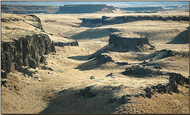
Source: http://wordpress.ed.pacificu.edu/jclark/files/2011/11/The-Missoula-Floods-Layer.kmz
|
|
5. The Willamette Valley
After racing through the Willamete Valley, floodwater began to fill the low elevation Willamette Valley. As the water temporarily settled, it dropped sediment that it had carried from upriver. This is why this valley's soil is so fertile today |
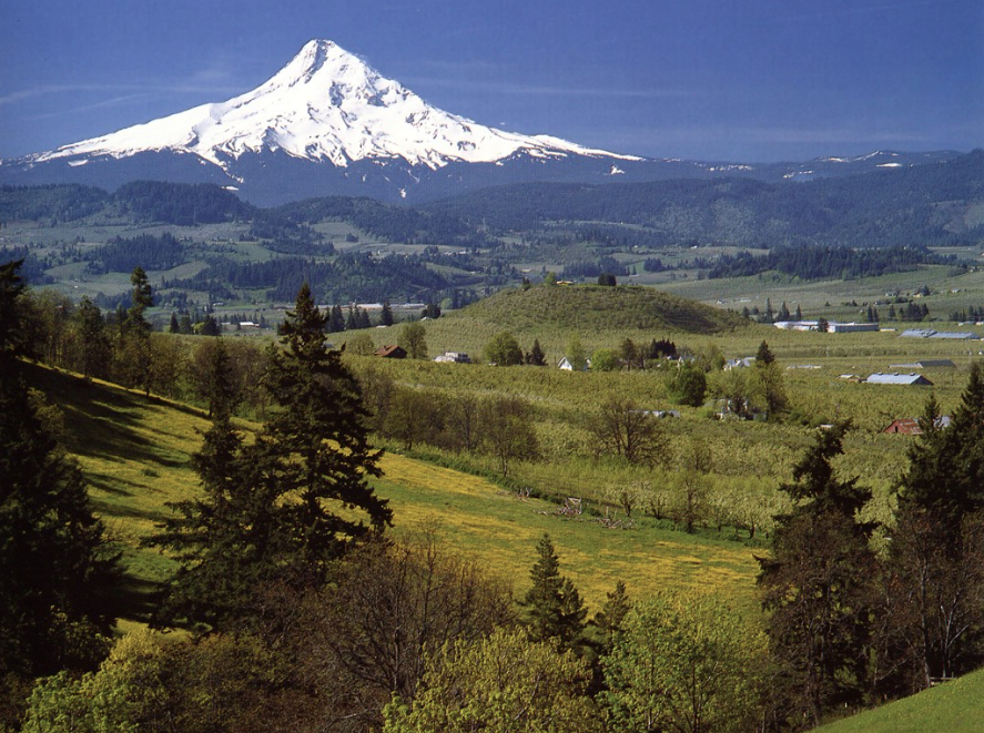
Source: http://api.ning.com/files/5rOKh5yrOt0eYhSwaUEwox7OsfP24pVmZFbxY60p
MvG3E1E4N
XePmUNFh*nJtEoGO
rzefnQY*s5tkOpnliHlX
on6Ubtv7l6N/mthood.jpg
|
|
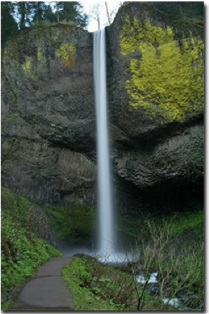
6. The Columbia River Gorge
The floodwaters did not create the Gorge, rather, they scoured and steepened its walls. Creek junctions with the Columbia were torn away, leaving the creeks to plunge over the lip of the newly cut gorge in a series of spectacular waterfalls. This quick erosion left many layers of volcanic rock exposed. |
Source: http://wordpress.ed.pacificu.edu/jclark/files/2011/11/The-Missoula-Floods-Layer.kmz
|
|
7. Glacial Lake Missoula
Glacial Lake Missoula was a prehistoric proglacial lake in western Montana that existed periodically at the end of the last ice age between 18,000 and 15,000 years ago. The lake measured about 3,000 square miles and contained about 500 cubic miles of water, half the volume of Lake Michigan. The lake was the result of an ice dam on the Clark Fork caused by the southern encroachment of a finger of the Cordilleran Ice Sheet into the Idaho Panhandle (at the present day location of Clark Fork, Idaho at the east end of Lake Pend Oreille). The height of the ice dam typically approached 2,000 feett, flooding the valleys of western Montana approximately 200 miles eastward. It was the largest ice-dammed lake known to have occurred. |

Source: http://wordpress.ed.pacificu.edu/jclark/files/2011/11/The-Missoula-Floods-Layer.kmz

Source: http://wordpress.ed.pacificu.edu/jclark/files/2011/11/The-Missoula-Floods-Layer.kmz
|
|
8. Yeager Rock
The Missoula Floods were so powerful that they were able to strip away 200 feet of topsoil and carry huge boulders from the underlying lava rock downstream. These boulders were picked up and carried in the floods only to be stranded in fields and prairies when the floodwaters subsided. Some boulders, called glacial erratics, were rafted on icebergs and transported great distances from their source by the floods of Glacial Lake. Yeager Rock is one such example of these glacial erratics. |
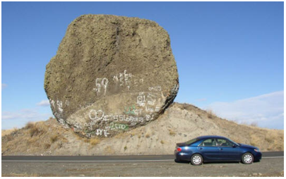
Source: http://wordpress.ed.pacificu.edu/jclark/files/2011/11/The-Missoula-Floods-Layer.kmz
|
|
9. Dry Falls
During the Missoula Floods, water over 300 feet deep poured over the 350-foot cliffs of Dry Falls. At three miles wide, Dry Falls is five times the width of Niagara Falls. The large plunge pools at the base of Dry Falls were created by these floods. Once the floods were over and the river returned to its normal course, the falls were left dry. |
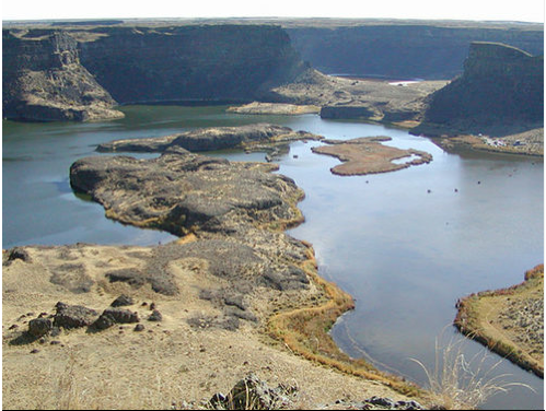
Source: Google Earth User - Douglas Kaynor
|
|
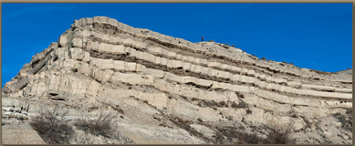
10. Sediment Layers From Multiple Floods
Lakes were formed by during the massive flooding, but often times these lakes were only temporary as they slowly drained. In these temporary lakes, many layers of sediments are found situated on top of one another; each layer represents a separate filling of the lake. No one is sure how many floods there actually were but most estimates put it at somewhere around 40! Hint #1: Numbers 2, 5, 8 and 9 are the easiest. Do them first if you are having trouble. Hint #2: If you are still having trouble, try turning on the photos Google Earth provides. They may give you a better sense for what is in that area. Answers: 1-B 2-J 3-C 4-G 5-I 6-H 7-A 8-F 9-E 10-D |
Source: http://wordpress.ed.pacificu.edu/jclark/files/2011/11/The-Missoula-Floods-Layer.kmz
Sources:
1. http://www.wordpress.ed.pacificu.edu/jclark/files/.../The-Missoula-Floods-Layer.kmz 2. http://www.glaciallakemissoula.org/story.html 3. http://www.nasa.gov/topics/earth/features/megaflood-legacy.html 4. http://pacificrimwine.com/about/story-of-missoula-flood/ 5. http://winefolly.com/review/gigantic-floods-made-washingtons-wine/ 6. https://www.youtube.com/watch?v=G_LRo3wIT34 7.http://wpg.forestry.oregonstate.edu/sites/wpg/files/seminars/1969_Bretz.pdf |
