|
GlaciologyThroughout the 2.5 millions years the Earth has been experiencing an ice age as ice sheets spread from the Arctic into the midlatitudes. It does so in intervals of glaciations that last approximately 70,000 years, separated by shorter interglaciation periods [1]. During the Wisconsinan glaciation, ice sheets had expanded to all of Canada and were advancing into the United States. The Missoula Floods coincided with the ending of the last ice age, and these major interactions between the cyrosphere, hydrosphere, and geosphere had large effects on the Earth system during its transition to interglaciation.
|

Photo Source: https://opinicon.files.wordpress.com/2012/04/laurentide-ice-sheet.jpg
|
|
Photo Source: http://nwcreation.net/images /geology/scablands/lakemissoula.jpg
|
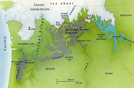
Hydrology At its core, the Missoula Floods involves a unique interaction between the cryosphere and the hydrosphere during the last episode of ice sheet expansion. About 15,000 years ago, a finger from the Cordilleran ice sheet spread south into the Purcell Trench of Idaho, damming the Clark Fork River between mountain ranges. Aided by glacial meltwater, Lake Missoula formed here and grew to hold 530 cubic miles of water, larger than Lake Erie and Lake Ontario combined. When the damn broke, water could flow for days at 60 times the discharge rate of the Amazon River and the massive mass of ice and water flooded parts of Idaho, Washington, and Oregon an. Once the lake was emptied, the glacier would advance again, and a cycle of damming and flooding occurred dozens of times for a period of 2000 years [2]. These large discharges of water contributed to the rising sea level at the end of the glaciation period, which rose 100 feet every 1000 years from glacial meltwater. On a broader spectrum, sea level rise lowers earth’s albedo, which raised temperatures, which melted more ice.[3]
|
Geomorphic Features These floods had profound effects on the geography of the area as the mass of water travelled 430 miles to the Pacific Ocean. This huge surge of water was able to create incredible rates of erosion and sediment transportation and created unique features through the stages of the journey. Within former Lake Missoula, erosion from the drainage tore out 360 feet of bedrock and created ripples in the land up 35 feet high (A). As it moved to the Channeled Scablands, it removed entire layers of topsoil and bedrock, created 40 feet deep potholes in basalt, and carved immense channels in the land (B). Continuing down, the river met several gaps that could were too narrow to maintain the flow of the water, despite some, like Wallula Gap, being over a mile long. These would form a hydrologic dam where the water would form temporary lakes, whose shoreline left layered sediments south of the Scablands (C). The floods met with the Columbia River, and scoured and expanded its already existing gorge (D). These steepened walls are disproportionate with normal water flow of the area, leaving plunging waterfalls throughout the gorge. Throughout all of the area, large amounts of sediment had been deposited in the form sand or gravel bars, and large boulders, called erratics, trapped in ice have been dropped far from their place of origin. [2][4][5]
|

Image A: Ripples of Former Lake Bed
Photo Source: https://s-media-cache-ak0.pinimg.com/736x/38/3f/bf/383fbf998dfeeb2b1f70250bc992bb0f.jpg 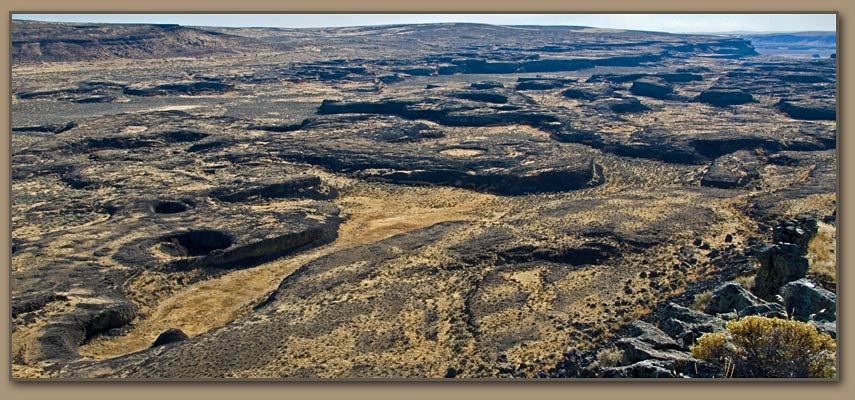
Image B: The Channeled Scablands featuring potholes & deep channels
Photo Source: http://hugefloods.com/Lake-Missoula-Flood.jpg 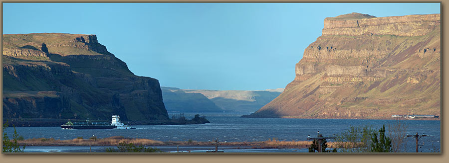
Image C: The Wallula Gap with layered sediment
Photo Source: http://www.nature.com/nature/journal/v482/n7385/images/482314a-f1.2.jpg 
Image D: The Columbia River Gorge
Photo Source: http://www.nature.com/nature/journal/v482/n7385/images/482314a-f1.2.jpg |
Sediment and Nutrient Recycling The floods transported thousands of square miles of sediment, but included with them were large amounts of mineral nutrients. Glaciers grind rocks until they make a make a fine powder, and melting glaciers transported this nutrient substance to Lake Missoula. As the floods crossed the scablands, they became even more nutrient enriched as the water eroded the area's fertile deposits of wind-blown dust called Loess, leaving only small islands surrounded by exposed bedrock. Nutrients, along with erratics, were deposited in the temporary lakes due to the reduced flow. Much of Oregon’s fertile farmland, like Willamette Valley, can be attributed to these deposited nutrients. The rest of the sediment and nutrients were carried to the Pacific Ocean, releasing 360 cubic miles of sediment that traveled as far as 700 miles from the mouth. The transportation from glaciers to the Ocean is an important part in the recycling of sediments and nutrients.[2][3][6]
Gravel bars deposited during flooding demonstrate the strength of erosion transportation during the floods.
Photo Source: http://www.pbs.org/wgbh/nova/megaflood/scab-nf.html |
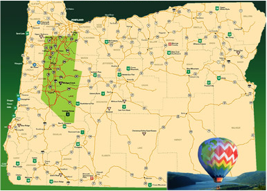
The fertile farmland of Oregon in the Willamette Valley was once apart of the Missoula flood plains, and thank its fertile farmland to the sediment transported.
Photo Source: http://www.guidetooregon.com/maps/map_willamette.jpg |
Citations:
[1] Kump, Lee R., James F. Kasting, and Robert G. Crane. The Earth System. 3rd ed. Upper Saddle River, NJ: Pearson Prentice Hall, 2004. Print.
[2] Lee, Keenan. "Missoula Floods." (2009): 1-19. Colorado School of Mines. Web. 03 Apr. 2016.
[3] Alt, David. "Inside Glacial Lake Missoula." PBS. PBS, 20 Sept. 2005. Web. 3 Apr. 2016.
[4] "Glacial Lake Missoula and the Ice Age Floods." Glacial Lake Missoula and the Ice Age Floods. Montana Natural History Center, n.d. Web. 10 Apr. 2016.
[5] Johnson, Kendall L. "Lake Missoula and Its Floods." Rangelands 33.5 (2011): 37-39. JSTOR [JSTOR]. Web. 03 Apr. 2016
[6] Normark, William R. "Extensive Deposits on the Pacific Plate from Late Pleistocene North American Glacial Lake Outbursts." The Journal of Geology 111.6 (2003): 617-37. JSTOR. Web. 03 Apr. 2016.
